Towards a Web GIS-based approach for mapping a dengue outbreak
Abstract
Dengue, a most common vector (mosquito)-borne viral infection causing serious illness and death mostly among children, is commonly widespread throughout the tropical and sub-tropical areas with local/regional variations. There are some important environment factors which are affecting the dengue spread. This study was conducted to evaluate the spatial outbreak patterns of dengue in Lahore District which was among the majorly affected areas. The environmental factors affecting the spread of the
disease have been mapped in a GIS using all the spatial and tabular data obtained from different sources. Land surface temperature (LST), rainfall, land use/land cover, Normalized Difference Vegetation Index (NDVI), and population density are considered the major factors which are affecting the dengue spread. The results depicted some particular trends. Areas with high population density were found to be more infected for the simple reason of lack of hygiene measures and water accumulation on the unpaved roads (as these areas were mostly low-income pockets of the city). Some posh areas although with comparatively low population density were also found to be infected from dengue due to the reason that they mostly had lawns and swimming pools in their houses which are the most active breeding sites of the mosquitoes.
Keywords Word: Dengue . Geographical information system (GIS) . Outbreak patterns . Lahore
Introduction
Dengue is the most common vector-borne viral disease of humans producing concerns worldwide with an estimated 50 million infections occurring annually with 500,000 reported cases of dengue hemorrhagic fever (DHF) causing at least 12,000 deaths per year (Barbazan et al. 2000). As far as the most affected areas are concerned, prevalence of dengue is highest in tropical areas of Asia and America, with 50 to
100 million estimated cases of dengue fever (DF) and 250,000 to 500,000 cases of DHF per year as explosive outbreaks in urban areas (Honório et al. 2009). Dengue was first introduced in Pakistan in 1982 when 12 out of 174 blood samples evidenced its presence. In Pakistan, the first outbreak of dengue was reported in 1994 but the attack went unnoticed as only few people become infected.Analysis shows that the outbreaks mostly happen during seasons having combination of rains and moderate to high temperatures. It usually adopts a cyclic pattern, starting from a lower level of outbreak then taking its peak position with a greater number of patients and afterwards ending up again with a less severe outbreak. This cyclic pattern normally occurs due to the change in environmental conditions such as
temperature, humidity, rainfall, change in land use, etc. (Barbazan et al. 2000).
The situation became more alarming and challenging when a more severe outbreak occurred in 2010 when thousands of people got caught by this viral disease. Aside from changing climatic conditions, this high incidence rate of dengue could be probably due to availability of potential breeding sites of the mosquito such as water ponds (either in the form of swimming pools or stagnant water), tire shops, rubbish heaps, construction sites, etc. A narrower look at all the above-mentioned land use types concludes that there is a strong relationship between water accumulation sites and dengue breeding sites. Secondly, it showed a greater incidence rate in urban areas as compare to the rural ones as
urban areas are normally equipped with water ponds in the form of swimming pools and stagnant water over green areas (parks, private lawns, etc.).According to World Health Organization (WHO), the optimum
rainfall and temperature are very crucial factors controlling mosquito’s breeding and effective transmittance.
Cooler temperatures impart lesser adult mosquito population and vice versa. Moreover, extreme temperatures whether low or high affect its breeding rate adversely. Also, high temperature with good rainfall provides ideal conditions for its growth (Rocha et al. 2009).
Conclusion
From all the above discussion and the analysis performed, the following facts can be concluded:
- Remote sensing technology is highly capable of providing information regarding a number of significant factors such as LST, land cover/land use, health of vegetation (NDVI), etc. These were some of the major environmental factors that influence dengue outbreak. Here, the satellite imagery of Landsat TM was used to obtain these factors but they can be precisely known using the data of IKONOS, ASTER, etc. as well.
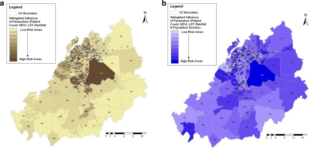
- The study depicted different spread patterns, each depicting a sound cause. One of the significant patterns was the spread in posh areas due to the reason that this mosquito breeds over clean water. The areas in these houses mostly have water pools and gardens in them which are suitable sites for the breeding of mosquitoes. Secondly, this study is based on the number of reported cases, so being posh areas; the residents have an easy access to the medical facilities to report against the disease.
- Another pattern identified was a high number of patients in low profile areas having residents belonging to a middle class family. In this scenario, three major reasons were identified other than the environmental factors which were a greater population density, least access to the medical facilities, and lack of cleanliness. The unpaved roads causes the rain water to accumulate and form little water ponds which is the favorite site for the breeding of mosquitoes.
- The remote sensing in combination with the GIS technology has been found to be very effective to plan against some disease surveillance system. The risk map has been generated taking all the environmental data obtained from different sources in the GIS environment using weighted overlay function. These are the initial findings which were made using the available data that depends on the precision of the data.